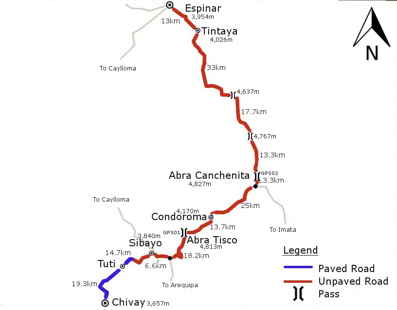
Chivay – Sibayo – Abra Tisco – Condoroma Dam – Abra Canchenita – Espinar/Yauri
A nice route heading out of the touristy Colca Canyon town of Chivay and over two high passes to Yauri (to give it its correct name – most people just call it Espinar though as it is the capital of Espinar district). In between the two passes comes a descent back to the Rio Colca at Condoroma, however as this is far upriver from Chivay the bridge crossing the river is above 4,000m. The middle section of the route from the turn off to Abra Tisco just after Sibayo and the junction just before Abra Canchenita has little traffic, but from this junction to Espinar there are quite a few lorries going to and from the big mine at Tintaya.
[scrollGallery id=7]
| Total dist. | Stage dist. | Description |
| 0km | Chivay (3,657m). Touristy town with facilities, including ATM. | |
| 19.3km | Leave Chivay on the paved road over an Inca bridge. After the initial descent to the bridge, climb all on tarmac to Tuti. Nice scenery. | |
| 19.3km | Tuti. Village with basic shops. | |
| 21.3km | Stick to main road. 14.7kms (5.5kms paved) of ups and downs to Sibayo (3,840m). Turn R at the start of town (L/straight goes direct to Caylloma) and descend to cross a bridge. 6.6kms from Sibayo arrive at a junction. | |
| 40.6km | Junction (3,900m). Turn L to Abra Tisco (signposted Cusco). | |
| 18.2km | Climb to Abra Tisco, some water sources. | |
| 58.8km | Abra Tisco (4,813m – GPS01). At the pass there is a junction. Go straight for the Condoroma Dam. | |
| 16.6km | Descend a bit, then climb to 4,800m, 3.5kms from the pass. Then all descent to Condoroma village (13.7kms from pass, saw no facilities) and then to bridge over Rio Colca. | |
| 75.4km | Bridge over Rio Colca (4,140m). Start climbing again. | |
| 25.4km | Climb is constant to 4,740m, then there are ups and downs to the pass. 22.1kms from the Rio Colca you get to a junction – str/L to Espinar, R to Arequipa. Until this point there is virtually no traffic, but after there are mine trucks. | |
| 100.8km | Abra Canchenita (4,827m – GPS02). The highest point on the route. Not a very defined pass – the road is above 4,700m for quite a while and the road undulates near the pass. | |
| 31.0km | More undulations to a high point (4,770m) 13.3kms from Abra Canchenita. Then a descent to two small villages (at about 4,450m) before climbing to another high point. | |
| 131.8km | High point (4,640m). Finally begin proper descent. | |
| 46.0km | Descend to 4,100m then climb on the road that passes by the mine at Tintaya which is the source of all the traffic. Descend again and 33kms from the 4,640m high point get to a signposted junction (4,030m). R to Tintaya, L to Espinar. 13kms from junction to Espinar. | |
| 177.8km | Espinar (3,950m). Town with accommodation options, restaurants etc. Tourist office which can arrange tours to the impressive Tres Cañones in the upper Apurimac valley. |
| Details | |
| Time taken – 3 days and amount climbed – 3,140m | 7 hours: Chivay – Abra Tisco (1,600m climb). 5 hours: Abra Tisco – Abra Canchenita (840m climb). 6 hours: Abra Canchenita – Espinar (700m climb). |
| Traffic | Some until turn-off to Abra Tisco. Very little from this turn-off until junction before Abra Canchenita. Mine trucks from here to Espinar. |
| When we cycled | Mid October 2010. |
| Difficulty | 3/4 |
| How much we had to push on this route | Not at all |
| GPS Point | Description | Lat/Long/Altitude |
| GPS01 | Abra Tisco | 15.4365 S, 71.3712 W, 4,813m. |
| GPS02 | Abra Canchenita | 15.2792 S, 71.1594 W, 4,827m. |
View Chivay – Espinar (Yauri) in a larger map


Error thrown
Call to undefined function ereg_replace()