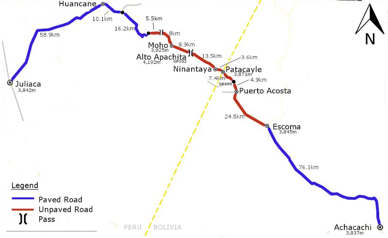
Achacachi – Puerto Acosta – Ninantaya – Moho – Huancane – Juliaca
This road goes round the east and north shores of Lake Titicaca, avoiding the busy roads from La Paz to Juliaca via Desaguadero or Copacabana. There are no immigration facilities on either the Bolivian or Peruvian sides of the border if you cross by this route, which means it is a bit of effort getting the necessary stamps in your passport.
Before leaving Bolivia you need to go to the immigration office – open Monday-Friday, 09:00-17:00(?), closed for lunch 12:30-14:30 – on Av. Camacho in La Paz for your exit stamp. We were given 48hrs to leave Bolivia after getting our stamp, which was fine as our bikes were in Achacachi. 48hrs is not really enough though if you have to cycle from La Paz to the border, and it may be possible to plead for an extra day, though it shouldn’t really matter as there are no Bolivian officials at the border to check when you leave. In Ninantaya (Peru) the friendly police took our details and told us we had to go to Puno for our entry stamp – no time restrictions so we cycled to Juliaca then took the 45 minute minibus to Puno. The immigration office in Puno is just off the Plaza de Armas – it took 5 minutes and no hassle for us to get our entry stamp. (See update comments for changes and other possibilities in regard to this.)
Going in the opposite direction from Peru to Bolivia, it is necessary to get your exit stamp in Puno, then cross into Bolivia and obtain your entry stamp in La Paz. See Tom and Sarah’s excellent Bicycle Nomad site for details.
The scenery on this route is pleasant enough, though the way described below which we took rarely has views of Lake Titicaca or any snowy mountains. There are a few options though, so it is possible to cycle nearer the lake at a few points (see update comments). The ripio part of the route is nice and quiet, but the road from Huancane to Juliaca is busy with no real hard shoulder.
| Total dist. | Stage dist. | Description |
| 0km | Achacachi (3,837m). Large town with accommodation, shops, restaurants, internet, but no ATM. | |
| 76.1km | Leave Achacachi on the paved road to Sorata. At junction after 1.1kms go L/straight for Ancoraimes (R to Sorata). Flat for 35.6kms to Ancoraimes. Then small climbs and descents to Escoma. | |
| 76.1km | Escoma (3,845m). Town with accommodation, shops, restaurants and busy market on Sundays. | |
| 36.8km | Leave town from the plaza on a ripio road, crossing a bridge just outside town. 24.5kms on ok ripio to a junction just before Puerto Acosta. From here there are route options. One turns L at the junction, goes through town (where there is a police post on the main square – we spoke to them but as we had our exit stamp they didn’t need us to do anything there), then climbs the hill above town. This route goes closest to Lake Titicaca. We however went straight at the junction, coming to another junction (3,880m – GPS01) on a bend after 4.9kms. At this new junction we went straight on a small road to Patacayle as we were told it was more direct. The surface was terrible however and the going to the border very slow. Staying on the main road (i.e. L at this second junction) is probably quicker as the surface is presumably better. Going the direct way it is 7.4kms from the second junction to Patacayle. | |
| 112.9km | Patacayle (3,870m). Tiny border village with a small shop. | |
| 26.0km | 3.6kms to Ninantaya. Speak to the police by the church and register your entry to Peru. However it is necessary to go to Puno for your passport entry stamp. Gentle climb to Alto Apachita (4,192m – GPS02) 13.5kms from Ninantaya. Descend 8.9kms to Moho. Surface all fine. | |
| 138.9km | Moho (3,920m). Town with accommodation on the main square, restaurants, shops. Didn’t see an ATM – best to buy a few Soles in La Paz beforehand. | |
| 98.7km | (Two options when leaving Moho. One is to take a smaller road nearer Lake Titicaca; we went on the main road.) Climb, on this main road which is still ripio, to a high point (4,120m), 8.0kms from Moho. Tarmac begins 5.5kms later. Fast descent, then flat to turn-off to Vilquechico, 16.2kms from the start of the tarmac. 10.1kms from the Vilquechico junction is the large town of Huancane (facilities). Then 58.9 flat kms on a busy road to Juliaca. | |
| 237.6km | Juliaca (3,842m). City with facilities (except immigration for which you have to go to Puno) but little else to recommend it. |
| Details | |
| Time taken – 3 days and amount climbed – 1,900m |
6 hours (headwind): Achacachi – Escoma (620m climb). 4 hours: Escoma – Border (350m climb). 3 hours: Border – Moho (430m climb). 6 hours: Moho – Juliaca (500m climb). |
| Traffic | Plenty on paved road from Achacachi to Escoma. Little from Escoma to Moho. Some traffic from Moho to Huancane, then busy from Huancane to Juliaca. |
| When we cycled | Early October 2010. |
| Difficulty | 2 |
| How much we had to push on this route | Less than 0.5kms (bad surface) |
| GPS Point | Description | Lat/Long/Altitude |
| GPS01 | Junction after Puerto Acosta | 15.4973 S, 69.2596 W, 3,879m. |
| GPS02 | Alto Apachita | 15.3888 S, 69.4259 W, 4,192m. |
View Achacachi – Juliaca in a larger map
Nearby routes: North Yungas Juliaca to Chivay


Error thrown
Call to undefined function ereg_replace()