Abancay – Antabamba – Huacullo – Cotahuasi
This is fantastic, but extremely difficult, high altitude route through southern Peru, with a lot of climbing, steep gradients and sections of poor surface. In the middle part of the route the road is above 4,500m for 130kms during which time it crosses five 5,000m passes, before descending into the spectacular Cotahuasi canyon.
Finding water isn’t much of a problem as the road passes streams at least a couple of times each day. Between Antabamba and Chinchayllapa settlements are few and you can only resupply at basic shops in Huacullo and Culipampa. We took 4 days of food from each of Antabamba and Culipampa, just to be safe.
| Total dist. | Stage dist. | Description |
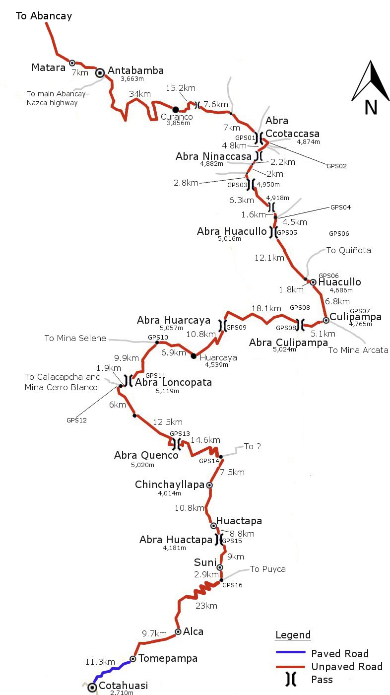
| 0km | Abancay (2,420m). Large town with all facilities. The Hotel Imperial was good. | |
| 72.6km | Descend from town on the main, paved road. Low point after about 15kms at 1,770m. Gentle undulating climb upvalley to Sta Rosa. (Don’t turn off the paving after 46kms up a road signposted ‘Antabamba’ – we were told this doesn’t go to the town of Antabamba.) | |
| 72.6km | Santa Rosa. Village with restaurants and accommodation. Turn L onto unpaved road to Antabamba. | |
| 78.5km | Upvalley to Antabamba. The only decision to make is about 36.8kms from Santa Rosa where you have to go straight (up) at a junction, just after the village of Huancapampa. Pass through the small village of Matara 7kms before Antabamba. | |
| 151.1km | Antabamba (3,660m). Shops, restaurants, accommodation, slow internet. | |
| 34.0km | Pass through town and after 1.1kms go straight (signposted ‘Arequipa’) at a junction where the main road goes R round a hairpin. Climbs and descents to another junction (3,810m) 19.2kms from Antabamba. Stay straight for Huacullo (L goes to village of Chuñohuacho). Descend to another junction (go straight/down) just before a bridge (3,620m, 24.3kms from Antabamba). Mostly climb to village of Curanco. | |
| 185.1km | Curanco (3,860m). Tiny village, didn’t see any facilities. | |
| 29.8km | Descend 1.4kms from Curanco to a bridge (3,800m). Climb 13.8kms to high point (4,520m). 6.8kms from this high point reach a stream (the first drinkable water we saw since the bridge). 0.8kms later a track joins from the L, but stay straight on the main road. Climb for 7kms more to Abra Ccotaccasa. | |
| 214.9km | Abra Ccotaccasa (4,870m – GPS01). | |
| 4.8km | At the pass a road joins from the L. Stay straight, and descend to a junction (GPS02) 0.7kms from the pass. Go R at the junction (L to ?) towards Ninaccasa. In another 0.9kms go straight at a junction towards Huacullo (L is signposted ‘Los Apus de Ninaccasa’). In a further 0.4kms stay straight/R on the main road at a junction. Shortly after is the low point at about 4,760m, followed by a sometimes steep 4.8km climb to Abra Ninaccasa. | |
| 219.7km | Abra Ninaccasa (4,880m). | |
| 7.0km | Descend 1.4kms to Mina Oro Vega which is off to the L. Stay R on main road. 0.8kms further on stay L on main road at a junction on a hairpin. Descend to 4,710m then climb through a tiny settlement and up to a junction by some houses, 2.8kms from Mina Oro Vega. Stay straight and climb 2.8kms to a pass. | |
| 226.7km | Pass (4,950m – GPS03). | |
| 6.3km | Descend to a low point (4,770m) 4.9kms from the pass. Soon after there is a stream to wade (the first water we saw since the stream before Abra Ccotaccasa), then climb steeply for 1.4kms to another high point. | |
| 233.0km | Pass (4,920m). | |
| 6.1km | Descend steeply for 1.6kms to a junction (4,770m – GPS04). Go R. Start climb to pass 1.8kms later. Road climbs 250m in 2.7kms to the pass. | |
| 239.1km | Abra Huacullo (5,016m – GPS05). | |
| 13.9km | Descend 50m past a lake, then climb to another high point (5,000m) 2.5kms from the pass. Descend and 5.1kms from the high point go R at a junction. In a further 4.5kms meet the Huacullo-Azuca road . Go R and descend, arriving in Huacullo after 1.8kms. | |
| 253.0km | Huacullo (4,690m – GPS06). Small village with basic accommodation, restaurant, shops. | |
| 11.9km | Go through the village and in 6.8kms get to Culipampa – (4,770m – GPS07) a smaller village with restaurants, accommodation, shops. Turn R (L goes to Mina Arcata) onto the Arcata-Selene road and climb to a pass. Occasional mine traffic. | |
| 264.9km | Abra Culipampa (5,024m – GPS08). | |
| 18.1km | Descend 5.5kms on a sandy surface to low point (4,720m) at a stream. All rideable. Climb 3.5kms to a high point (4,910m) on a good surface. Descend 2.5kms on another quite sandy surface to another low point and river (4,750m). Climb 6.6kms to the pass. | |
| 283.0km | Abra Huarcaya (5,057m – GPS09). | |
| 17.7km | Descend 50m then a small climb to a high point at 5,040m, 1.8kms from the pass. Descend 9kms to Huarcaya (4,540m), a tiny settlement with no facilities. Follow the valley (crossing 2 bridges) for 6.9kms to a junction. Road surface still ok. | |
| 300.7km | Junction next to blue hut (GPS10). Go L onto small road. Don’t miss this turn – it would be easy to overlook and continue straight on the main road to the Selene mine. | |
| 9.9km | Climb gently up valley for a while, then begin climbing steeply to the pass. Coropuna comes into view just before the pass. | |
| 310.6km | Abra Loncopata (5,119m – GPS11). | |
| 7.9km | Descend 1.9kms to a junction (GPS12). Go L to Cotahuasi. (R goes to Calacapcha and Mina Cerro Blanco). Descend 6.0kms to a low point, crossing under huge power lines not long before reaching the low point. | |
| 318.5km | Low point/river (4,700m). | |
| 12.5km | Climb 4.5kms to high point (4,990m). Descend 4.5kms to junction/low point (4,830m) – stay straight and climb. Climb 3.5kms to a pass. | |
| 331.0km | Abra Quenco (5,020m – GPS13). | |
| 14.6km | Gentle, then steep descent. After about 11kms drop below 4,500m for the first time in 130kms. | |
| 345.6km | Junction by a bridge over river (4,220m – GPS14). | |
| 7.5km | Don’t cross the bridge. Go R and stay on the same side of the river. Climb 2.6kms to a high point (4,360m) then descend 4.9kms to Chinchayllapa. | |
| 353.1km | Chinchayllapa (4,010m). Small village with shop. | |
| 19.6km | Very steep 2.8km descent to river (3,760m). Climb 2.0kms to the small village of Churca (3,860m). 6.0km to Huactapa (small village with shop). Then 8.8km climb on switchbacks to the final pass. | |
| 372.7km | Abra Huactapa (4,181m – GPS15). | |
| 11.9km | Descend 6.0kms to the village of Maghuancca (3,770m, shop), then 3.0kms to the small village of Suni (3,580m). Continue descent, then climb 90m to a junction 2.9kms from Suni. | |
| 384.6km | Junction (GPS16). Go R to Cotahuasi (L to Puyca). | |
| 44.0km | Bumpy, 10km descent on switchbacks to Rio Cotahuasi. Follow the river downstream for 13kms to Alca (town with accommodation, restaurants, internet, shops). Continue 9.7kms to Tomepampa (pretty town with some tourist facilities including accommodation), then 11.3kms of paved road to Cotahuasi. | |
| 428.6km | Cotahuasi (2,710m). Town with accommodation, restaurants, shops, internet, a bank that will change USDs, but no ATM. |
| Details | |
| Time taken – 7 days (this was rushing, best to take 8 or 9) and amount climbed – 9,160m | 4 hours: Abancay – Sta Rosa (660m climb). 9 hours: Sta Rosa – Antabamba (2,040m climb). 13 hours: Antabamba – Huacullo (2,870m climb). 5 hours: Huacullo – Huarcaya (940m climb). 8 hours: Huarcaya – Huactapa (1,510m climb). 6 hours: Huactapa – Cotahuasi (1,140m climb). |
| Traffic | Plenty to Antabamba, then not very much. 2 vehicles in 2 days from Antabamba to Huacullo. A few mine vehicles an hour from Huacullo to the junction past Huarcaya. Virtually nothing from there to Chinchayllapa. A couple of vehicles an hour from there to the Cotahuasi valley, then busier. |
| When we cycled | Mid November 2010. |
| Difficulty | 5 |
| How much we had to push on this route | 12kms |
| GPS Point | Description | Lat/Long/Altitude |
| GPS01 | Abra Ccotaccasa | 14.4594 S, 72.6470 W, 4,870m. |
| GPS02 | Junction | 14.4606 S, 72.6450 W, 4,830m. |
| GPS03 | 4,950m Pass | 14.5229 S, 72.6611 W, 4,950m. |
| GPS04 | Junction | 14.5607 S, 72.6292 W, 4,770m. |
| GPS05 | Abra Huacullo | 14.5879 S, 72.6292 W, 5,016m. |
| GPS06 | Huacullo | 14.6552 S, 72.5728 W, 4,690m. |
| GPS07 | Culipampa | 14.7064 S, 72.5551 W, 4,770m. |
| GPS08 | Abra Culipampa | 14.7137 S, 72.5913 W, 5,024m. |
| GPS09 | Abra Huarcaya | 14.7148 S, 72.7011 W, 5,057m. |
| GPS10 | Junction | 14.7383 S, 72.7932 W, 4,620m. |
| GPS11 | Abra Loncopata | 14.7897 S, 72.8348 W, 5,119m. |
| GPS12 | Junction | 14.7970 S, 72.8453 W, 5,020m. |
| GPS13 | Abra Quenco | 14.8760 S, 72.7670 W, 5,020m. |
| GPS14 | Junction | 14.8925 S, 72.7041 W, 4,220m. |
| GPS15 | Abra Huactapa | 15.0063 S, 72.7058 W, 4,181m. |
| GPS16 | Junction | 15.0623 S, 72.7026 W, 3,640m. |
View Abancay – Cotahuasi in a larger map
Error thrown
Call to undefined function ereg_replace()