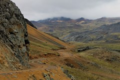
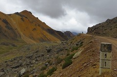
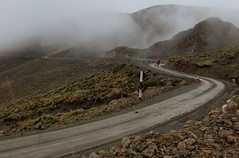
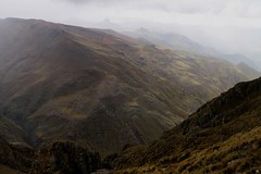
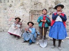
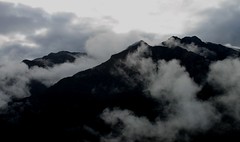
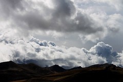
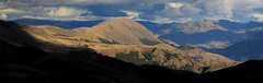
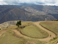
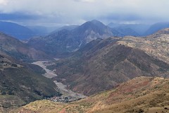
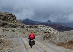
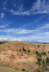
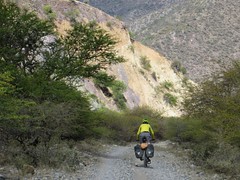
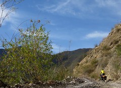
The route passes through a whole host of traditional villages and a number of towns, including Vilcashuaman which was an important Inca centre and is home to some interesting ruins. Despite the region being reasonably well populated, the roads described here are little used by traffic, so there is plenty of quiet riding to be enjoyed.
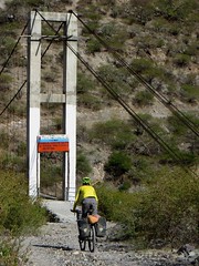
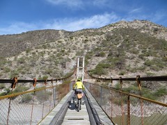
Note that while the normally reliable Peruvian road maps show a sizeable road from Vilcashuaman to Andahuaylas via Saurama and Uranmarca, there is no bridge or way across the Rio Pampas at this point. The pedestrian bridge over the Rio Pampas which the route described here crosses is the only way across this huge river for hundreds of kilometres.
Supplies are easy to find, as is water, which is a bonus because as with all routes in the Peruvian Andes, we can’t stress highly enough how important it is to go light – it will make the climbs a lot more enjoyable. Here is a list of kit we took for the ride – around 15kg each – and here is our blog post about the ride on Pikes on Bikes.


| Distance | Altitude | Description |
|---|---|---|
| 0 | 4230 | Junction on paving in Licapa. Head for Ayacucho. |
| 17 | 4760 | Abra Apacheta. |
| 28.2 | 4310 | R to Paras, on dirt road. |
| 30.6 | 4380 | Sta Fe. Small village, no facililities. |
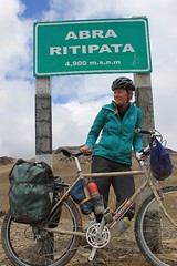
| 44.1 | 4950 | Abra Ritipata. There’s no water on the descent until a village at 3850m (a bit off route, below the road), so if climbing up in the opposite direction, make sure you stock up. |
| 45.6 | 4910 | L for Paras. R goes to Carhuaccocc. |
| 76.9 | 3520 | R to Paras. |
| 79.7 | 3340 | Paras. Shops, restaurants. |
| 83.4 | 3130 | L. |
| 91.5 | 3120 | San Martin. Small village, no facilities. |
| 95.5 | 3010 | R in Lloqllascca/Nuevo Cangallo. |
| 95.7 | 3000 | L to Totos. R to Vilcanchos (0.6km away – accommodation, restaurants, shops). |
| 97.5 | 3120 | L to Totos. |
| 103.2 | 3320 | Veracruz and Totos. Shops, restaurants, accommodation. Pick up water, as there’s none until 3750m. |
| 104.1 | 3360 | L. |
| 124.6 | 4500 | Abra Tucuccasa. |
| 130.1 | 4200 | Tuco. A few houses and a very basic shop. |
| 135.1 | 4360 | High point. |
| 138.2 | 4290 | R to Chuschi. Straight goes to Ayacucho. |
| 142.4 | 4060 | First Huertahuasi. Small village, no facililties. |
| 146 | 4100 | Bigger Huertahuasi. Small village no facilities. |
| 146.3 | 4060 | L. |
| 152.3 | 4260 | High point. |
| 164.4 | 3530 | Llacctauran(?). Small village, no facililties. |
| 172.9 | R to Chuschi. | |
| 175 | 3120 | Chuschi, Plaza de Armas. Accommodation, restaurants, shops. |
| 178.5 | 3280 | Uchuyri. Small shop. |
| 181.6 | 3350 | Ccotarara. |
| 184.6 | 3350 | Cancha Cancha – big village. Shops, restaurants. |
| 188.7 | 3390 | Straight. R to Chacolla, below rd. |
| 193.9 | 3200 | L on paving. R goes to Sarhua. |
| 197.1 | 3240 | Pomabamba. Shops etc. |
| 202.5 | 3540 | Abra. Still paved. |
| 202.6 | 3530 | R to Llullucha on ripio. Great shortcut. Could just stick to paving and go through Pampacangallo to Cangallo. |
| 204.4 | 3670 | Abra. |
| 206.7 | 3520 | Llullucha. |
| 207.5 | 3520 | L. |
| 212.2 | 3310 | R. |
| 214.5 | Pacupata. Go R. | |
| 218.5 | 3040 | Paving starts (but soon more will be paved). |
| 220.2 | 2980 | Wawapuquio. Termales. |
| 226 | 2680 | Turn off L for Vischongo, Vilcashuaman. Continue straight for Cangallo (about 1km away, at 2570m – shops, accommodation, restaurants, internet. La Casona is a good place to stay.) |
| 233.1 | 3120 | Putica – village with shops. |
| 246.6 | 3740 | High point. |
| 249.4 | 3700 | Straight. |
| 253.9 | 3590 | Patahuasi. Small village. |
| 257.5 | 3440 | Ñuñunhuayco. |
| 259.7 | 3280 | R in Paccha. |
| 263.2 | 3140 | Stay L. |
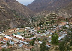
| 266.1 | 3140 | Vischongo. Town with shops, accommodation, restaurants. |
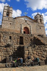
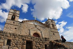
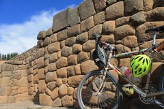
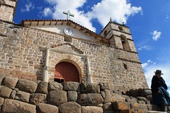
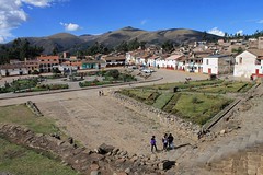
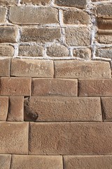
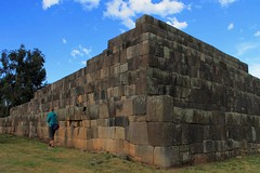
| 285.8 | 3490 | Vilcashuaman. Big town with shops, accommodation, restaurants, internet, good Inca ruins. |
| 288.4 | 3600 | Viscachayocc. Small village. |
| 289.4 | 3610 | R to Putacca. |
| 292.3 | 3640 | L. R is for Accomarca. |
| 294 | 3670 | Putacca. |
| 298.5 | 3890 | High point. |
| 301.6 | 3810 | Raymina. Basic shops. |
| 305.8 | 3970 | Pass. |
| 307.9 | 3870 | Straight to Pitecc. L to Punturco, R to Accomarca. |
| 313.5 | 3670? | Pitecc. Shops. Go L. |
| 317 | 3340 | Pongococha. Shops. |
| 330.2 | 2400 | Anta. Basic shop. |
| 332.9 | 2200 | Cross pedestrian bridge over Rio Pampas. |
| 343.1 | 2880 | Socos. Tiny village. |
| 348.5 | 3140 | R. L descends to river. |
| 350 | 3240 | R. L to Belen (just off rd – probably has some facilities). |
| 355.7 | 3710 | High point. |
| 356.8 | 3640 | Straight. R goes to Pamparca. |
| 359.6 | 3670 | Chalcos. Big village, shops. |
| 361.7 | 3770 | High point. |
| 369.7 | 3400 | Chilcayocc. Shops. |
| 370.6 | 3470 | R. L goes to Jatunrumi. |
| 375.5 | 3940 | Pass. |
| 380.7 | 3710 | Putongo. Shops. |
| 385.4 | 4100 | Stay L. R goes to a mine. |
| 394.6 | 4350 | Abra Putongo. |
| 395.8 | 4310 | Go L onto small track, after Km14 marker. |
| 401.6 | 4400 | Abra Jayuri. |
| 404.8 | 4350 | Hit Querobamab-Paico road. Go L. Join at about km17. |
| 408.3 | 4320 | R to Autama. Straight goes to Paico. |
| 421.2 | 3800 | R in Autama, a village with shops. L goes to Paico. |
| 426 | 3680 | L. |
| 431.3 | 3440 | Soras. Shops, accommodation. Go R. |
| 440.8 | 3410 | Larcay. Shops. Termales. |
| 450.6 | 3390 | Junction in Chicha. Go L. R goes to Puquio. |
| 451.1 | 3400 | R. Straight is for Andahuaylas. |
| 455.5 | 3620 | L onto small road, at Km4+44 marker. Straight goes to Negromayo. |
| 464.7 | 3840 | Torohuichccaña. Small village with no facililties. |
| 470 | 4000 | Abra Millamar. |
| 487.3 | 3370 | Sañayca. Shops. |
| 497.9 | 2670 | Paving on Nazca-Abancay highway. Went L. |
| 528.6 | 2370 | Sta Rosa. Turn off for Antabamba, and tough route to Cotahuasi. |
| Details | |
| Distance (of which paved) | 529km (77km) |
| Time taken | 7 days |
| Amount climbed | 12,000m |
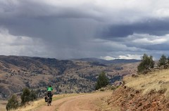
| Traffic | Some around the towns and on the paved highways, but otherwise very little. |
| Best time to cycle | May – September |
| When we cycled | Late October 2013 |
| Difficulty | 3/4 |
| How much we had to push on this route | Not at all |


Great route. I did it late November-early December. Rain was late this year. Some updates and dome shorcuts for this route.
We came cycling from Lima to Chinca Alta (paved) and then heading to the mountains on gravel road. You should climb 2000m in 21 kms. Was hard and no water at all.
-Licarpa, hard to find a restaurant.
-Abra Ritipata one of the easiest passes, even if it is almost 5.000
-Totos, leaving the town just after the arch you should go left to climb Tucuccasa, but if you go right you will avoid the big climb. Someone told me the ascent was stony. You leave Totos Km marker 50 and you reach Chumai Km marker 35. Then you start climbing for about 10 kms. Once you are up you should go around the mountain all the way and you will join Andes by bike route on his 146,3 km (You save 7 kms and a bit of climb, about 300m). There was no water on the way down until Llactuaran (very small village)
-Vilcashuaman. only one place has cabinas, but the municipality has free wifi, they probably will give you the code. They have water shorcuts during day and night.
-Cangallo is big town, and La Casona looks nice,only 5 soles more expensive than the old Municipality hotel. No wifi both of them but cabinas in town.
– The shorcut andes by bike suggest is on a hard climb. Maybe 2 kms but hard. Some drivers said it was not a shorcut. But the downhill was on a very nice landscape. This is the day you maybe arrive to Cangallo.
-From Cangallo to Vischongo the climb is hard at the beginnig, but later is better. But a long climb. On the top you have a flat section, after this you must go right. You will see electric poles on the right and you should go that way. Always up.
– The downhill to Anta is on very bad condition. Stony. The way up after the river, and crossing the only (pedestrian but cars cross it) bridge it is not that bad. In Pomacocha ask for Madelein a nice woman with a small shop that maybe cooks for you. Then is just downhill to the river. Anta is small nothing.
-Chilcayoc, maybe they let you stay in the school. Not very friendly at first sight, but later on they smile. No internet.
-Larcay is small and hot. I did not use the thermas.
-Abra Millamar, they work on the road. Explosions to make it wider. Maybe in 2 years there is asphalt.
-Abancay firestation are helpful and let you stay. But before Abancay you have a big climb, and afer it a long, long on, on asphalt, if you want to go to Cusco.
This is the story on my web. I did the route with a friend that had joined me, Eric. He was fit with a 40 kgs bike (mine 75kgs) and we did it in 12 days. http://www.biciclown.com/index.php?mmod=diari&file=details&iN=493
Enjoy the Andes, and thanks to Andesbybike for his great info.
álvaro the biciclown, http://www.biciclown.com 10 years on the road.
Nice section! Thank you guys for sharing it!
We cycled it in May and the weather was pretty good all the time. We did it from South to North.
– Chilcayoc, we stayed in the old Posta de Salud. They were very kind
– Cangallo, “La Casona” is clean, hot shower (10 soles per person)
– If you cycle from South to North like us, climbing the long Abra Ritipata, it is good to know you can find water and camp next to a water hole (pozo). It is in km 31,6 (look for road km marker 31), at 4325m, just below a hairpin. Perfect spot and great views
The road from Belen to the bridge and from there to Pongococha is steep and vey rocky.
If you want to check our site and Tripline:
http://www.bike2reality.wordpress.com
And our video from those days:
https://vimeo.com/131089200
Ricard and Alba
Thanks for sharing the route, we just finished it (August 2015) going south.
After you cross a river before the Mina Esperanza, water becomes extremely scarse. We were lucky to be able to camp by a house, a woman showed us to a little ‘water hole’, so we didn’t have to get over the next abra.
Abra Ritipata is stunning. We found the waterhole/mini lake mentioned by Ricard and Alba on the downhill – thanks for the tip. The water is extremely dirty unfortunately so you should have a good filtration system.
Totos is small but has a few shops and a newly built/refurbished hotel (we paid 15). There is an alternative route from Totos to Chuschi (leaving town turn right) which we chose. It is also possible to ride straight from Veracruz, avoiding Totos (not missing out).
Chuschi has free wifi at her plaza, which only occasionally worked though. Lots of accommodation options.
Vilcas Huaman: nice historic town, we stayed in the hotel 13 inkas (clean, friendly, well-priced). Couldn’t find wifi but bites has computers with Internet. Good Chifa at the plaza!
Anta is as mentioned tiny. People are used to cyclists passing through and let you camp on the football field (concrete). Be aware, there are lots of animals, from cows to donkeys and dogs, that might keep you awake at night. It is very campable down by the bridge, if we had known we would’ve carried on and camped by the river.
We camped next to the public toilets in Chiclayoc, just ask at the municipality, they unlocked the toilets for us. Going southward, you’re faced with two steep climbs. They are not long in distance but still very tough.
Before Autama are a number of streams you could camp at. After Autama are a few other spots as well.
In Soras, a very nice police officer, Angel, brought us to the hidden away and unused playground to set up camp. We could shower, charge batteries, and fill up on water at the police office. Good sized shops.
On the downhill to Sañayca, after a series of small switchbacks, the main road carries on straight whereas the pike’s route hangs a left. We almost passed the turn as it has been blocked off (possibly temporary), still passable though. Going straight probably merged onto the same route a bit later but we can’t confirm as we didn’t take it.
We made it from Soras to Santa Rosa in one day. The highway part at the end is very quick, all just downhill (but headwind). The last (?) hotel on the right side as you head out of town has spacious rooms to fit the bikes, comfy beds and a courtyard, 15 for the both of us.
Road surfaces were all manageable, we’re on fatbikes though, so we would probably have a harder time telling the difference. We rode this section in 8 days, some longer and some more relaxed.
on normal bike without suspension the road surpfaces can be pretty ugly ( bumpy, big solid stones)
the shop in Tuco has : Pasta, sardines, carrots, tomatoes, crackers and gaseosas but be aware that the owner might be out in th emountains herding cattle during hte day. another lady opended the shop for us. as the “village” is very spred out could be difiicult to find someone
km 138: talked to someone who said its easier to go straight and then right on the next crossing some 8 to 12 km further down. We took that way. From That crossing its 25 km to Chushi, 7km gentle climb. I dont know if its really easier but also possible.
first Abra after Pomabamba: the shortcut probably isnt one. our Gps said from Chushi to cangallo 53 km and Pikes 52km. If you stick to the pavement, there will be up and down after Pampacangallo. but you can go from the ABra on the paving about 7 km down . there a sign “desvio a pampacangallo” and the paving turn about 90 degree to the left. If you go 90 degree right on the dirt its all downhill to Cangallo. The dirtroad goes back to the paving after 4 or 5 km. Its pretty bumpy , but no climbs that way
In Putica: shops are all closed during the day, as theyre improving the road for the next 3 month
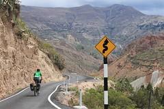
From Paccha to Vilcashuaman; quite some traffic