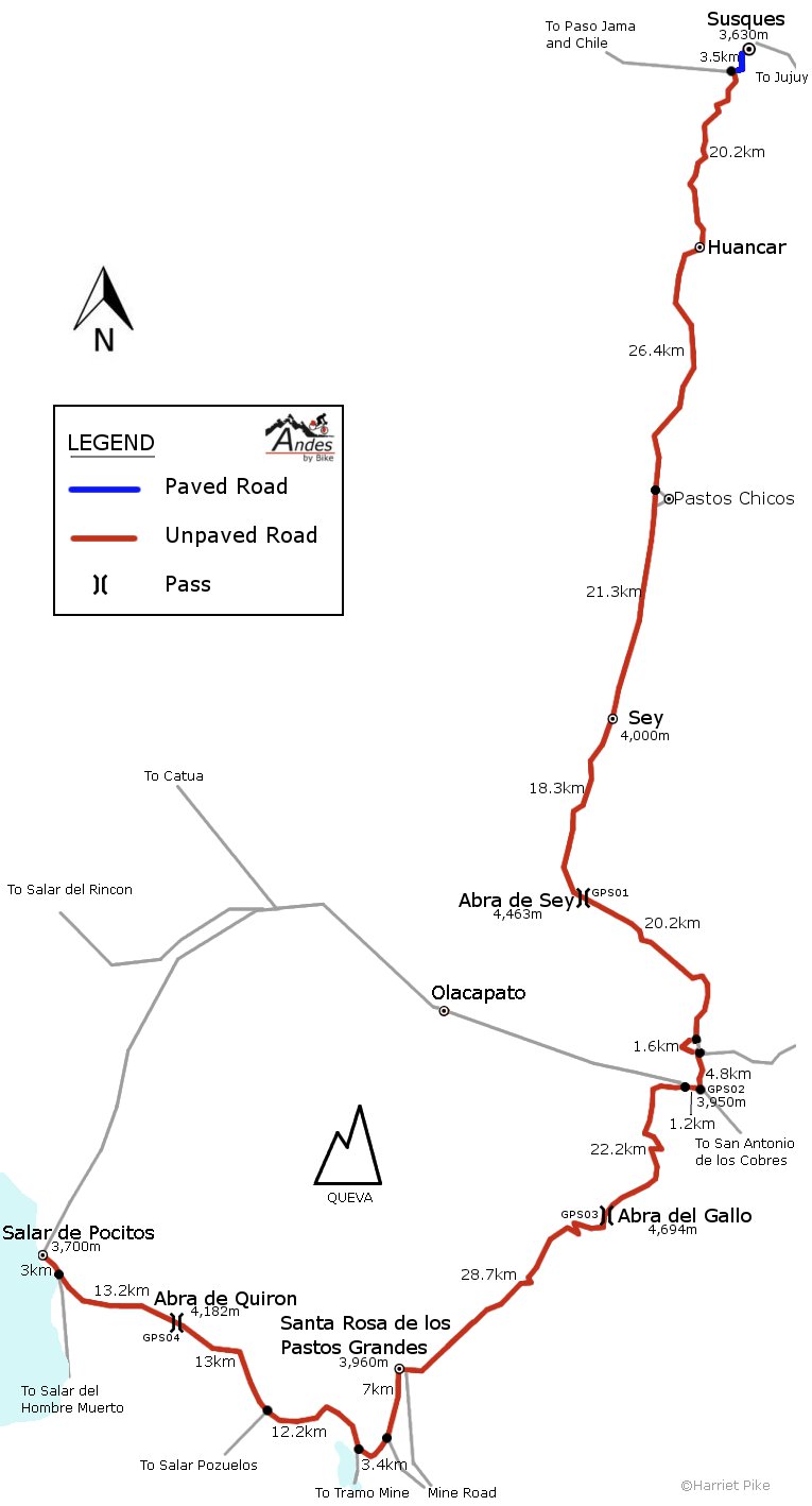
Susques – Sey – La Polvorilla – Abra del Gallo – Sta Rosa de los Pastos Grandes – Salar de Pocitos
This is a nice and quiet route on the Puna in northwest Argentina. From Susques to the impressive La Polvorilla viaduct there is virtually no traffic, but in a couple of sections the road is sandy. There is some mine traffic on the way to Santa Rosa but it goes quiet after this tiny village, which is a good base from which to climb Nevado Queva. The road is sandy and corrugated in places on the way to Pocitos, and the state of the road is the main difficulty on this route as there isn’t a huge amount of climbing to do and any gradients are mostly gentle.
| Total dist. | Stage dist. | Description |
| 0km | Susques (3,630m). Scruffy town with ATM, accommodation, restaurants and shops, but no bike shop. Internet connection wasn’t working when we were there. | |
| 71.4km | Take the road towards the Paso Jama and in 3.5kms turn L at a signposted junction. 20.2kms from here to Huancar (village with shops) on a hilly road. Much flatter for 26.4kms to turn-off to Pastos Chicos (small village a few kms off the road to the E). 21.3kms of gentle uphill to Sey. | |
| 71.4km | Sey (4,000m). Village with basic accommodation, restaurant, shops, and an internet place that we didn’t try. | |
| 38.5km | Climb for 18.3kms to the Abra de Sey (4,463m – GPS01), the descend to La Polvorilla. | |
| 109.9km | La Polvorilla viaduct. Possible to get water and food at the coffee shop. | |
| 7.6km | Go under the viaduct and in 1.6kms go R at a 4-way junction (no signs). Descend 4.8kms to RN51 (3,950m, water in stream). Turn R (GPS02) on main road towards the Paso Sico, but 1.2kms later go L at a junction. | |
| 117.5km | Junction. Go L to Santa Rosa de los Pastos Grandes (signposted). | |
| 22.2km | Climb – initially by a stream. There is some traffic going to the mines south of Santa Rosa. | |
| 139.7km | Abra del Gallo (4,694m – GPS03). | |
| 28.7km | Descend. After 9.2kms the road splits and the two run parallel for a few kms. The road is flat to Santa Rosa. | |
| 168.4km | Santa Rosa de los Pastos Grandes (3,960m). Tiny, welcoming village with 2 very basic shops, but no accommodation. (We turned R (north) up a small track at the start of the village to go and climb Nevado Queva – the high mountain to the north.) | |
| 35.6km | Leave Santa Rosa heading south, on the road past the school. After about 7kms stay R at a junction, sticking to the main road (mine traffic goes L). 10.4kms from Santa Rosa stay R again at a junction (L goes to the Tramo mine). 12.2kms later there is a junction to Salar Pozuelos (L), stay straight on the main road. 13kms climb to Abra de Quiron. | |
| 204.0km | Abra de Quiron (4,182m – GPS04). | |
| 16.2km | Descend down a nice valley. After 13.2kms reach the turn-off to Antofagasta de la Sierra (L), but stay straight to reach Salar de Pocitos in a further 3kms. | |
| 220.2km | Salar de Pocitos (3,700m). A few basic shops (better stocked than Santa Rosa), a restaurant, but no accommodation. Fill up your water bottles if heading to Antofagasta. |
| Details | |
| Time taken – 4 days and amount climbed – 2,710m | 7 hours: Susques – Sey (800m climb, headwind) 5 hours: Sey – Ruta 51 (570m climb, headwind). 6 hours: Ruta 51 – Santa Rosa (870m climb, headwind). 5 hours: Santa Rosa – Salar de Pocitos (470m climb). |
| Traffic | Very little from Susques to Ruta 51. Some mine traffic from there to the turn-off just after Santa Rosa, then very little to Salar de Pocitos. |
| When we cycled | Early December 2010. |
| Difficulty | 3/4 |
| How much we had to push on this route | 1.5kms (sand) |
| GPS Point | Description | Lat/Long/Altitude |
| GPS01 | Abra de Sey | 24.0881 S, 66.5123 W, 4,463m. |
| GPS02 | Join Ruta 51 | 24.2405 S, 66.4105 W, 3,950m. |
| GPS03 | Abra del Gallo | 24.3409 S, 66.4934 W, 4,694m. |
| GPS04 | Abra de Quiron | 24.4260 S, 66.8705 W, 4,182m. |


No updates yet.